GMap Editor v1 User Guide > Settings > Publish
Map Publish Settings
Changing the "Publish" settings will only apply in the preview / published map.
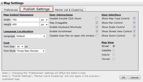
Map Embed Dimension
The map dimension can be changed by pixel or percentage. This map dimension will be shown on Preview or Published Map only.
User Interactions
The changes of "User Interactions" will be reflected on Preview page or Published Map only.
| Disable Double Click Zoom | Double click and zoom in/out is enabled by default. While select this "Disable Double Click Zoom", you can prevent the map from being zoom in/out by double click. |
| Map Draggable | Dragging is enabled by default. While disable this "Map Draggable", you can prevent the map from being dragged. |
| Enable Keyboard Shortcuts | Keyboard shortcuts are enabled by default. Visitors can use Google Map keyboard shortcuts such as ↑,↓,←,→ to move the map or +. - to zoom in/ out the map in the preview/ published map. (P.S. This Keyboard Shortcuts are not applicable in our Editor) While disable the "Keyboard Shortcuts", you can prevent the map from being controlled by the keyboard. |
| Enable Scroll wheel | The scroll wheel is enabled by default. While disable this "Scroll wheel", you can disables scroll wheel zooming on the map |
Language Localization
The language of the map can be changed. See also the supported list of languages
Font
| Font Size | Set font size in the map. (from 8px to 23px) |
| Font Style | Set font style in the map. (Options: Arial, Times New Roman, Courier New Courier, Verdana, Georgia) |
User Interface
The changes of "User Interface" will be reflected on our GMap Editor and also preview/ published map.
All options here is enabled by default.
| Show Map Type Control | The initial enabled/ disabled state of the Map type control. | |
| Show Pan Control | The enabled/ disabled state of the Pan control. |  |
| Show Scale Control | The initial enabled/ disabled state of the Scale control. | |
| Show Street View Control | A StreetViewPanorama to display when the Street View pegman is dropped on the map. If no panorama is specified, a default StreetViewPanorama will be displayed in the map's div when the pegman is dropped. | |
| Show Zoom Control | The enabled/disabled state of the Zoom control. |
Map View
Select the mode of map view of your map.
| Street View |  |
| Satellite View |  |
| Hybrid View |  |
| Terrain View |  |
[ Top of Page ]