Instant Cloud-based Mapping Application
No installation - No download - Runs directly in Browser - Accessible Everywhere on all devices!
- Create and edit maps in browser
- Copy and paste to embed map on website
- Pinpoint locations by address or latitude / longitude
- Visualize business data
- Import locations from CSV
- Custom Google Maps
- Heat Maps
Map Example Highlight
Census Data and Demographics Map
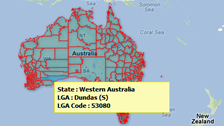
- Using shape files of administrative divisions like states or provinces, or statistical regions like census tracts or regions, and overlay them on a base Google Map
- Suitable for sales and business data analysis
Cloud-based Mapping Application
Create interactive maps
Using a country or world map template

- Create your own map, pinpoint places & simply customize, no coding required.
- Create heat map with legend or a colored map for presentation purpose.
- Various ready made regional maps to select from
Create custom Google maps
Plot multiple locations or draw routes on map

- Make an accurate map with locations or routes down to street level & display text or photos in dialog boxes.
- Plot multiple locations on a map with addresses, zip codes or lat/ long data.
- Generate data-driven maps with markers from a database, Excel or CSV file.
Import your own image maps
Make static maps come alive & interactive

- Convert static image of various formats into a interactive map.
- Add pins, legends, infoboxes and draw routes to annotate the clickable map.
- Insert your maps into websites, blogs or share via links with a few clicks.
Maps built with iMapBuilder Online
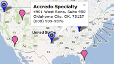
Store Locator
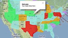
Sales territory map
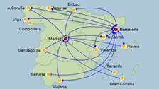
Travel and flight route map

Distance and directions maps
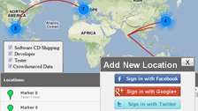
Crowdsourced map
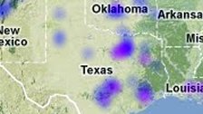
Heat map with multiple data sets
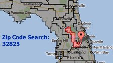
ZIP code search to show congressional districts
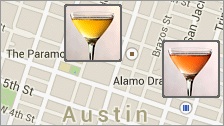
Map of restaurants